Friday, June 21, 2019

History of the Canal du Midi


The Canal du Midi was declared a UNESCO World Heritage site in 1996. The canal comprises 328 structures including aqueducts, bridges, tunnels, and locks. Waters of the Canal du Midi twist and turn through the countryside, passing acres of vineyards, fields of wheat and sunflowers, and numerous towns and villages.

In 1667, Pierre-Paul Riquet (1609-1680) designed and began building the canal for the benefit of transporting goods between the Mediterranean Sea and the Atlantic Ocean.
Portrait of Pierre-Paul Riquet
It took 14 years to complete the canal using shovels and pickaxes, and later, gunpowder. The canal opened to boat traffic in 1681, six months after Riquet’s death. The canal carried over 100,000 tons of cargo and a million passengers each year. Before long, the Bordeau railway opened and commerce along the canal all but dried up. The Canal du Midi is one of the oldest in Europe and is still in operation. Today the canal is used mainly for tourism.

The idea of a canal linking the Mediterranean and the Atlantic dates back to Roman days; and was also a popular idea during the 1500’s; but the cost and obstacles were considered to be insurmountable. Pierre Paul Riquet, a salt tax collector from Beziers, began to study how such a project could be accomplished and came up with a workable plan. In 1663, accompanied by the Archbishop of Toulouse, Riquet was able to convince the famous finance minister Colbert of his proposal, and in turn, Louis XIV of the value of his project. Most importantly, Riquet was able to solve the water supply issue by diverting several small streams in the Black Mountain (near the town of Castelnaudary) towards the canal’s highest point.

Statue in honor of  Pierre-Paul Riquet in Toulouse
The first stone was laid for a reservoir in April 1667; and in November of the same year, work began on the first lock at Toulouse. The section between Toulouse and Trebes was completed in only five years, despite several modifications. Riquet designed the locks with an oval shape, which makes them so distinctive today. His attention to detail ensured that the canal would be long lasting and function well from the very beginning.

The second part of the canal from Trebes to Sete was begun in 1672 and proved more troublesome. A difficult terrain with many river crossings added to the costs and delayed the completion. A testament to Riquet’s genius, he chose the left bank of the Aude River, which kept the canal above the worst possible floods. (The Aude River gets its source from the Pyrenees, then runs to Carcassonne, and finally reaches the Mediterranean Sea.) The chosen course brought the canal to the foot of the Enserune Mountain, where the work was stopped by his opponents. But Riquet set his men to work digging a narrow passage through the hill or mountain. The Malpas Tunnel, begun in 1679, was completed in 1680, enabling Riquet to continue the canal towards his home town of Beziers. The tunnel was reinforced with a series of supporting arches, which proved to be safe, contrary to his opponents concerns. Riquet had just opened the first navigation tunnel in the world. Digging then continued quickly along the flat coastal plain. Completed and officially approved, the canal was filled with water in 1681. The Canal du Midi has operated without interruption for more than three centuries.

Thursday, June 20, 2019

France Latitudes - Locks & Lines


On June 20th we departed for a two-week boat trip on the Canal du Midi. Since we live in Anacortes Washington, we find it more convenient to fly out of Vancouver B.C.; it’s an easier drive to the Vancouver airport than to Seattle, and has better parking facilities with a quick sky-train that takes you directly to the airport. Our flight from Vancouver routed us to Toronto, with another flight to Paris connecting to Montpellier, France. At Montpellier, we used a taxi van to take us to the Le Boat Base at Port Cassafieres. After purchasing groceries and receiving instruction for our chartered Le Boat, we headed northwest along the Canal du Midi.

The Canal du Midi shown in green
The Canal du Midi is one of most famous canals in the world. Construction began in 1663 to link the Mediterranean to the Atlantic Ocean via the river Garonne from Toulouse, which empties into the Atlantic. The Canal du Midi descends from a summit east of Toulouse to the coastal plain of the Mediterranean through the hills of the Languedoc region between the Pyrenees and the Black Mountains. Since we were traveling northwest, we were ascending the many locks along this waterway.

There are 91 locks along the Canal du Midi, covering 240 km (over 149 miles). Rather than straight walls, like the locks in Seattle, the Midi locks are oval in shape, providing strength for the stone block construction. There are several locations where the locks are grouped, creating a ladder of locks in sets of 2, 3, 4, and even 6 connected chambers. Lock keepers attend most of the locks, which are now automated to open and shut the chamber doors (the locks are generally closed from noon to 1 pm for the lock-keeper’s lunch). When ascending the locks, two crew members disembark along the shore prior to the boat entering the locks, and walk up to the locks to receive lines from the boat.

Two crew members on the boat toss up the bow and stern lines to the awaiting crew members at the locks, who wrap the line(s) around a bollard. As the water rises to fill the locks, the lines are drawn in to take  up the slack, holding the boat fast against the lock walls to prevent bumping into other boats and the walls. Once the boat has risen and is level with the top of the lock, the two crew members handling the lines step aboard the boat to continue their journey to the next locks.
If your boat is short on crew members, one person at the top of the locks can toss the bow and stern lines back down to crew members on the boat, who can wrap the lines around the boat cleats and take up slack from the boat position rather than from above.

When descending the locks, the lines should be long enough to let out enough line as the water and boat go down, making sure that the line can run freely around the bollard. Descending is considered to be easier, since the boat enters the lock at the quay level allowing crew to simply reach out and loop the line around a bollard.

Friday, June 7, 2019

Arriving Home in U.S. Waters

Approaching John Henry's Marina in Pender Harbour

We departed Harmony Islands for our journey home. Exiting Jervis Inlet, we headed south along the east side of Nelson Island in Agamemnon Channel and ducked into Pender Harbour off Malaspina Strait to stay a couple nights at John Henry’s Marina. Pender Harbour contains various bays with ample moorage, public wharves, and several marinas. The area is populated with beautiful summer homes, condos, and high-end resorts.

From Pender Harbour, we continued down Malaspina Strait, which is within the Strait of Georgia, against winds of 10-15 knots and 3-foot seas; not bad for this area known for its rough conditions.
The difference in water color can clearly be seen near the mouth of the Fraser River
As we passed the mouth of the Fraser River, we could clearly see the difference in water color, caused by silt from the river meeting the saltwater of the Strait. There are three arms of the Fraser that enter the Strait — North Arm, Middle Arm, and the South Arm. As we approached the middle or main arm of the Fraser River, a clear demarcation in water color could be seen that continued another 10 miles as we cruised southward. The Fraser River discharges 20 million tons of sediment into the ocean each year.

Pleasure craft need to watch out for fast-moving commercial vessels
Large BC Ferries, cruise ships, tugs with barges, and container ships are frequently seen in the Strait of Georgia; pleasure craft need to keep a watchful eye and quickly move out of the designated commercial traffic lanes.

After entering US waters, we cleared customs by using the new ROAM app on our smart phone. Once the app is installed and you have entered all of the pertinent information about your vessel and all possible occupants, including passport numbers etc., the app is ready to use.
When crossing into U.S. waters, you simply select the “report arrival” button, which then asks some questions about which vessel you are reporting, and which travelers are reporting in that day. It also asks for the name of the master/captain and then tells you that your GPS location is being confirmed. The app also asks which State and location of arrival, along with some yes/no questions regarding fruits, vegetables etc. After answering all questions, you then hit “submit.” A trip ID number is then sent to your phone with a now “processing” message. After processing is completed, a message for a video chat with a customs agent is received, which requires hitting the “ok” button. If approved for clearance, you can continue on your way and will receive an email with your customs clearance number. If it is deemed necessary that an inspection of the vessel is required, you will be directed to the nearest customs dock.

After our successful clearance, we proceeded to Sucia Island in the San Juan's, where we anchored for the night for a late morning departure to our home port of Anacortes. This meant a pile of work would be waiting for us at home, not to mention cleaning and washing the boat, unpacking, washing clothes and sheets, and repacking for our next adventure. We are looking forward to cruising the canals of France (the Canal du Midi) with friend and Waggoner publisher, Mark Bunzel. After our return from France, we will be venturing north once again into the beautiful Pacific Northwest. Stay tuned for more reports from the field; changing latitudes and changing attitudes.

Tuesday, June 4, 2019

Anchorage in Harmony Islands?

High, rugged mountains rise steeply from the sea bottom in Hotham Sound

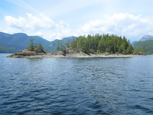
From Sturt Bay on Texada Island, we continued south on Malaspina Strait, turning eastward into Jervis Inlet to visit the Harmony Islands. Harmony Islands Marine Park is a small group of islands in Hotham Sound inside Jervis Inlet. High, rugged mountains rise steeply from the sea bottom, offering fjord-like views.

The beautiful Harmony Islands lie on the east side of Hotham Sound
The BC Marine Parks Forever Society recently provided a large donation for the purchase of a privately-owned island in the Harmony group, expanding this marine park. The addition of this island is currently in the process of being officially dedicated. Of the four islands, only one island (the middle one) remains under private ownership, with a house and dock on the island.

Anchorage can be taken on the east side of Harmony Islands
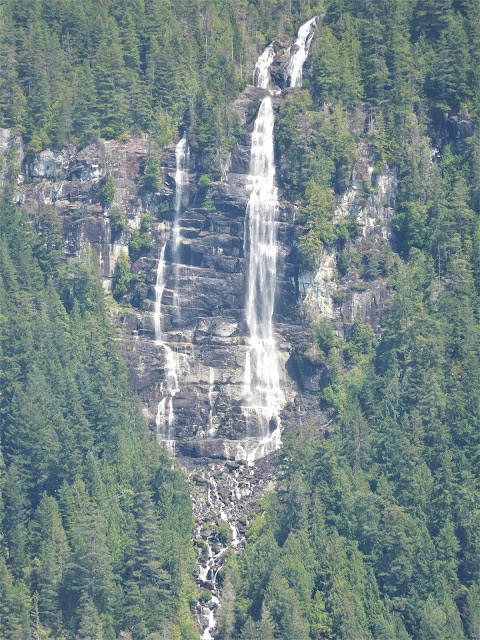
Currently, there are no public floats or stern-ties for the three islands within the Harmony Islands Marine Park. Anchorage can be taken behind the islands on the east side, just inside the neck of the south entrance. The gorgeous Freil Lake Waterfall, cascading down 1,400 feet, is nearby.
Freil Lake Falls


The Society’s goal is to protect recreational boating interests and to raise funds to support the B.C. Parks Department. Members of the Society are volunteers and work hard to protect the interests of all boaters from kayaks to sailboats and power boats. Part of the Society’s ongoing work is to acquire funds for the installation of stern-ties at marine parks and the acquisition of island property for future parks. These projects are possible thanks to donations from individual boaters, trusts, and foundations.

Monday, June 3, 2019

Limestone, Toothpaste, and Texada Island

Texada Boat Club docks at Sturt Bay on Texada Island

Departing Lund, we motored down the Strait of Georgia into Malaspina Strait, stopping at Sturt Bay on Texada Island. The Texada Boat Club offers transient moorage at their docks in Sturt Bay, with picnic tables under an open tent barge for impromptu social gatherings. People on the island are friendly and hard working.


Texada Island has a long history of mining, including iron, copper, silver, and gold. In more recent years, Texada has been a continuous source of high-quality limestone. The quarries can be seen along the hillsides while motoring along Malaspina Strait. Limestone is a sedimentary rock composed primarily of calcium carbonate in the form of the mineral calcite. There are several varieties of limestone, and Texada Island is known for its high-quality content.

Limestone plays an important role in a wide variety of products. Crushed limestone is used for road base and is also used as an aggregate in concrete. It can be cut into blocks and slabs for use in construction; it’s used for facing stone, floor tiles, stair treads, window sills, and many other applications. It can be used as a weather and heat-resistant coating on asphalt, impregnated shingles, and roofing. Crushed limestone is used in smelting and other metal refining processes. It’s even used as a filter stone for sewage disposal systems, and used as a sorbent to absorb pollutants in many coal-burning facilities.
Crushed Limestone
Farmers use limestone for treating acidic soils and in animal feed as a filler that provides calcium. Powdered limestone is also used as a filler in paper, paint, rubber, and plastics.

And, yes, limestone is even used in toothpaste — calcium carbonate is a mild natural abrasive which is less hard than tooth enamel so works well for cleaning; the calcium benefits in helping to develop and maintain teeth which are made up of calcium compounds. Limestone also gives toothpaste its white color.

Visitors can learn about the history of mining and quarrying on Texada, along with other interesting island history at the “Van Anda Museum” located a short distance from the docks at Sturt Bay on Waterman Avenue, adjacent to the elementary school.

Sunday, June 2, 2019

Lund, Past and Present


Cortes Island would be our turn-around point for heading back south and home to Anacortes, until our next voyage northward later in the summer. Pointing Got d’ Fever south, we cruised the west side of Cortes Island, checking out more anchorages along the way, then headed eastward via Uganda Pass and Baker Pass to Lund, located on the mainland “sunshine coast” of B.C.

The "Lund Small Craft Harbour"
Lund is a great jumping off point for Desolation Sound, where boaters often purchase last-minute groceries from the small community grocery store, or enjoy a meal out at The Boardwalk Restaurant or at the pub in the Lund Hotel. Having morning coffee and tasty cinnamon rolls at Nancy’s Bakery is another favorite treat. While many boaters appreciate Lund as a convenient stop, its fascinating history is often overlooked.

The Boardwalk Restaurant (right front portion was once a bunk house)
Take “The Boardwalk Restaurant,” for example, how many know that the dining area was a bunk house that was used by loggers in the 1920’s. The bunk house was towed from Toba Inlet into Lund Harbour in 1926 by creditors who had claimed it, when the logging company went into liquidation. After arriving at Lund, the bunk house was placed on piers and used for different purposes over the years. The bunk house served as a home for several different families and later became a coffee shop, then housed two different cafes. Major renovations took place in 2007 and 2008, retaining its original flooring still seen today.
The Community Rebuilt the Boardwalk in 2006
The first boardwalk was a single span cedar log, placed across Thulin Creek so that residents could walk between the bunk house and the hotel without getting their feet wet. In the 1980’s, the decaying old log was replaced by a hand-hewn boardwalk. By 2005 the boardwalk had deteriorated to the point of being unsafe. The community got together and sold engraved planks to raise funds for rebuilding the boardwalk, which was completed by volunteers in 2006.

Lund was founded in 1889 by two brothers, Fred and Charlie Thulin, from Sweden. After they settled the area, they named it Lund after the university town of the same name in their native Sweden. The brothers built a wharf; and later in 1892, a post office was established and a general store. By 1895, the brothers had built Lund’s first hotel, where a bottle of the best scotch was available for a $1.50. The basement served as a jail cell for rowdy patrons.
The Lund Hotel
When the hotel was destroyed by fire in 1915, a second hotel was built in 1918 and named the Lund Hotel. When the old hotel burned down and was being demolished, a skeleton was found in the cement pad under the front steps; sounds like an unsolved murder mystery to me. The Lund Hotel of today has been lovingly refurbished and is owned by the Tla’amin Nation, and businessman David Formosa.

During the 1930’s and 1940’s, shipwrights who came to Lund produced gill netters by the dozens, then larger boats, seiners, were built. Next came trollers, built between 1941 and 1951.
An Old Boat Shed From Earlier Boat Building Days
You can still see some of these old work sheds in the north cove (Finn Bay), adjacent to Lund Harbour. Jack’s Boat Yard serves boaters of today, offering dry-land storage and a boat yard where you can do your own work, or call on marine professionals to have the work done for you. Jack’s lift can haul out boats up to 50 tons and up to 20 feet wide.

Enjoying a Great Meal at The Boardwalk Restaurant
It’s always surprising how much more we appreciate a destination when we learn about its past. Somehow, connecting the past with the present brings all the pieces of the puzzle together for a broader view and perspective of what’s seen today.

We thank Rayana at The Boardwalk Restaurant for sharing much of Lund’s history with us. Her restaurant, by the way, is a wonderful place to enjoy some great food, including a delicious beet salad, seafood pasta, chowder and other great dishes. The restaurant definitely lives up to its slogan, “Great Food – Great Company.”

Saturday, June 1, 2019

How do they get tomatoes to Refuge Cove?

Peeking into the inner bay of Roscoe Bay

After a couple night’s stay in beautiful Prideaux Haven, we crossed Homfray Channel to take a look at Roscoe Bay on the east side of West Redonda Island. Roscoe Bay Marine Park is divided into an inner cove and an outer cove, separated by a drying shoal. Shallow draft boats can enter the inner cove at half-tide or better; going in on a rising tide is best. Having arrived during low tide, we stuck the nose of Got d’ Fever just outside the inner cove for a look, and then continued around West Redonda Island to Refuge Cove on the southwest side of the Island.

Boaters love stopping at Refuge Cove for supplies
Refuge Cove is a popular stop for boaters cruising the Desolation Sound region. It’s a busy place during the summer months with boats coming and going to pick up supplies from the historic store, buy fuel, or to enjoy a meal at the seasonal restaurant overlooking the docks. We arrived in the latter part of the morning, looking forward to purchasing some nice ripe tomatoes and other fresh fruit. We were informed that their store supplies would be arriving late that afternoon, which prompted several questions. “Where do the supplies come from and how do you get them here?”

The supply barge departing Refuge Cove
We got the full story that went something like this — We must first motor our barge across Lewis Channel to the public wharf at Squirrel Cove on Cortes Island, where a truck with a load of fresh supplies will be ready to meet us.
The truck with supplies at the Public Wharf in Squirrel Cove on Cortes Island
The truck, of course, had to take the ferry from Campbell River on Vancouver Island to Quathiaski Cove on Quadra Island, then drive across Quadra Island to Heriot Bay to get on another ferry to Whaletown at Cortes Island, to drive across Cortes Island to Squirrel Cove.
Loading the sled with supplies
Once we arrive at the public wharf at Squirrel Cove, we unload the truck and start stacking a makeshift sled with a yoke and rope that is used to carefully lower the sled, as it slides down the ramp to the dock below.
Lowering the sled down the ramp
We then start loading the barge, carefully stacking the boxes onto pallets for weight and balance. The process is repeated over and over again until all the boxes and produce have been unloaded from the truck.
The barge being loaded with supplies for the Refuge Cove Store
Then we are off once again, motoring across Lewis Channel in the hopes that the weather will hold for a safe crossing. Back at Refuge Cove, we pull the barge alongside the dock underneath a hoist, where the pallets of supplies are lifted up to the storefront. But we’re not done yet, everything must be stacked neatly on the store shelves and arranged in baskets for that added customer appeal.

What perfect looking tomatoes!
After hearing their story, we came to more fully appreciate the effort it takes to keep a remote island store stocked with goods throughout the busy cruising season. As they finished their story, they jumped in the barge and off they went, headed for Squirrel Cove to meet the supply truck. Squirrel Cove was our next stop, so why not take some photos of all the action. While visiting the public wharf at Squirrel Cove, sure enough, the Refuge Cove barge was there loading supplies to stock their store. It's amazing to think how far those tomatoes travel to reach Refuge Cove. There's also a country store at Squirrel Cove with marine supplies downstairs; they too, were gearing up for the summer months.

Von Donop Inlet on Cortes Island has lots of room to anchor
From Squirrel Cove, we motored northward up Lewis Channel and around the northern peninsula of Cortes Island, then southward to enter Von Donop Inlet. The Inlet is long, cutting far into the Island with lots of room for many boats to anchor.
Hiking the Von Donop Trail towards Squirrel Cove
A two-mile trail, starting at the southeast shore near the head of the Inlet, takes hikers to a road on the other side of the Island; from there it’s another one-mile walk to the public wharf at Squirrel Cove. The trail starts out flat and then becomes a moderate climb, consisting mostly of tall ferns, alder, and cedar making for a lovely forest walk.
The trail leads through B.C. Park land and through Klahoose First Nations land. This is also wolf country, with posted signage warning hikers to keep food put away and pets on a leash. No worries, we left both at home on the boat.